Return to Start Page

|
Nathen has apparently become infected by my interest in aircraft crash sites, and we have been talking about visiting various places ever since we saw the one on Mt. Lemon last September (or possibly the one on Mt. Graham in 2007). Originally we had planned to look for one reported in the Galiuro Mountains on Dec 26, but I aborted due to car problems. Finally, on Jan 2 we made the attempt. Although it doesn't look like much while standing on asphalt, Bassett Peak (at 7,671 feet) is the highest point in the Galiuro Mountains. According to a review on the internet, the crash site is located, "...on the east end of the highest saddle before the final climb to the summit." The trailhead, located at the end of a couple of miles of 4-wheel drive road, is at 4,990 feet (according to my GPS). The best guess is that the hike includes a 2,700 foot climb in a distance of 3.9 miles, making it a 13% grade overall. This sign (located at "the basin") suggest a lack of maintenance, but overall the trail is quite easy to follow. |
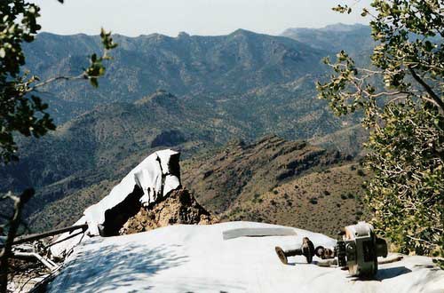
| We were not successful in locating the crash site, but this photo (lifted with the information below) off the internet, shows what we were looking for. This WWII Era crash occurred January 18, 1943. This aircraft was a B-24 Liberator (Serial # 41-11887), a four engine bomber of the same type in which Grandpa Paul (Barbara's Dad) served as a crew chief with the 8th Air Force in England. This particular plane had taken off from Davis-Monthan on a night-time bombing and gunnery training mission. It flew over the Sahuarita Bombing Range 15 miles south of Tucson, and was on its way back when the pilot became lost in a storm, and apparently chose the wrong heading. In dark clouds, the bomber flew into a peak in the Galiuro Mountains, 50 miles NE of Tucson, killing all 11 men on board. This Liberator remained missing for over 2 months, until it was finally located while searching for a B-17 that had gone down in roughly the same area. |

|

|
Given that this aircraft had a top speed of over 300 mph, the bombing range was 15 miles, and the crash site was 50 miles from the take-off point; these guys probably weren't lost very long. Considering time and speed, they had to have known that they had over-flown Davis-Monthan and Mt. Lemon, at 10,000 feet, was somewhere close. The crash site is just over 7,500 feet, and lacking access to the pilot's memory, the thought processes that brought them to that point are not intuitive.
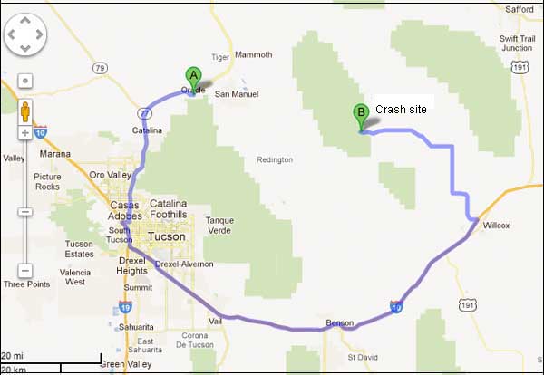
Air distance from Oracle to the trailhead calculates at 31 miles, but driving distance (per google maps) is 159 miles and takes 3 hours and 51 minutes. |
| In addition to Myself, Nathen, Terre, Ethan (age 8), and Kyle (age 7), made the hike. Note Ethan's rubber boots. Surprisingly, they caused him no problems, although he did start singing a chorus of, "Can we turn back now?" when we were about 20 yards from the car. Barbara went to Benson and looked after Rachel (age 3), and Landen (age 1), the two youngest family members while we hiked. |

|

|
The Galiuro Mountains are pretty rough terrain, and going where the trail doesn't, requires a high degree of motivation. Fortunately, the trail went where we wanted to go. |
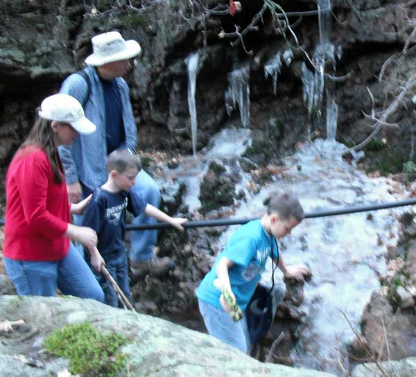
| I estimated the temperature to be in the 50's while we were hiking along the bottom of the canyon. Without wind, it was comfortable--if you kept moving. Toward evening it was a bit chilly, and I wouldn't have wanted to spend the night with only the equipment I carried. This blurry photo attempts to shows some of the ice we encountered. |

|

|
Most of the vegetation appears to keep its leaves during the winter, but you sure couldn't tell that by the deep cushion of leaves that covered the trail. In addition to the ponderosa pine, there was a lot of oak, and even some aspen. |
| When they were first introduced, I thought wilderness areas might be a good thing. But, like most things with government involvement, it didn't quite work out that way. Just in case you are wondering, you can't legally commit suicide by flying a hang glider off the top of Bassett Peak. I can think of no other reason to fly a hang glider into such rough country... |

|

|
More icicles, these almost a tall as Kyle. |
| One of the most puzzling observation on the whole trip was this tree. The blurry photo doesn't do it justice, but it has a diameter of about 14 inches, is more than 20 feet in length, and is hanging (at least 5 feet off the ground) wedged in a relatively small branch of a much smaller tree. I pushed on it with one of my hiking crutches, and it swung freely. This is a death trap if I've ever seen one... |

|

|
When we reached the location where we thought where the crash was to be, and didn't find it, Nathen did a little exploring. Upon returning home and consulting the internet, we calculated that we were still a mile short. Interestingly enough, we are unable to locate the crash in Google Map's satellite photos with a resolution that clearly shows the car in Nathen's driveway. |
| At an elevation of about 6,432 feet, we were starting to see significant patches of snow. Time constraints being what they were, we decided to call it a day and started back. Not being aware of the driving times and distances involved, we started much too late in the day. |

|

|
All things considered, it was a fun excursion. The only problem with it is that we didn't find the wreckage, and so will probably have to do it over again when we have more daylight. |

Driving home, we noted several flocks of large birds (which Nathen identified as cranes) flying in V formations. I don't think I have seen that many before. Nor, considering the season, could I say if they were coming north or going south... |